


Vijayawada SDI
This page brings together spatial data and analysis to understand how Vijayawada functions as a major urban, commercial, and mobility hub while addressing two critical urban challenges, air pollution caused by vehicular emissions and increasing traffic congestion due to rapid urban growth and VIP movements.
Vijayawada, the commercial capital of Andhra Pradesh, is strategically located along NH-16 and NH-65 and serves as one of South India’s busiest transport gateways. Its dense urban development, growing vehicle population, and concentration of economic activities in the city core have resulted in severe traffic congestion, reduced travel speeds, and worsening air quality.
To support sustainable urban planning and improved mobility management, the datasets and simulations presented here are part of two research projects: “Low Emission Zone (LEZ) Planning for Vijayawada” (CAR_24_01) and “Operational Plan for VIP Vehicular Movement in Vijayawada” (TUR_24_02). These projects aim to improve urban mobility, reduce environmental impacts, and support better planning decisions for a cleaner, more efficient, and liveable Vijayawada.
Low Emission Zone (LEZ) Planning for Vijayawada (CAR_24_01)
Vehicular traffic contributes significantly to urban air pollution, especially in core city areas where congestion and commercial activities are concentrated. In Vijayawada, these conditions have increased particulate emissions and created serious concerns for public health and environmental sustainability.
This project focuses on identifying and planning Low Emission Zones (LEZs) where access for high-emission vehicles can be restricted or regulated. The study includes delineation of LEZ boundaries, specification of operational hours, permissible vehicle categories, and preparation of active mobility plans that promote walking, cycling, and public transport.
The project also emphasizes stakeholder engagement and phased implementation strategies to support cleaner air, better mobility, and long-term sustainable urban development.
Operational Plan for VIP Vehicular Movement in Vijayawada (TUR_24_02 )
Vijayawada’s strategic importance as a commercial, administrative, and political center leads to frequent VIP visits and convoy movements, which often create traffic disruptions, delays, and operational challenges for commuters and enforcement agencies.
This project focuses on understanding traffic congestion patterns, identifying major bottlenecks at key junctions such as Benz Circle, Ramavarapadu, and Mahanadu, and assessing the impact of VIP movement on daily traffic operations.
Using traffic simulation and spatial analysis, the study aims to develop an efficient operational plan for smoother VIP vehicular movement while minimizing disruption to public mobility. The project supports better traffic coordination, reduced delays, and improved urban transport management across the city.
Vijayawada SDI Components
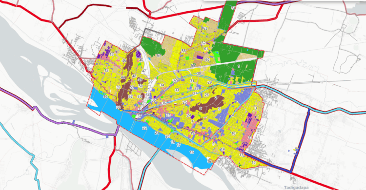
This map illustrates the Vijayawada Urbanizable Area as defined in the APCRDA Draft Perspective Plan 2050, highlighting the city’s future growth potential and planning framework. Alongside this, it overlays the existing Vijayawada Municipal Corporation (VMC) boundary and the ward divisions as they stand today, offering a clear picture of current governance units. By bringing together both present and future administrative extents, the map provides a comprehensive spatial reference for planning. This layered understanding is critical for developing operational strategies that align with both short-term management and long-term urban growth.
This map presents the seven potential routes identified between Gannavaram Airport and Amaravati that can be used for VIP vehicular movement through Vijayawada. Among these, the most efficient corridors will be shortlisted for detailed study and operational planning. The evaluation of these routes is based on multiple parameters.
This map presents the seven potential routes identified between Gannavaram Airport and Amaravati that can be used for VIP vehicular movement through Vijayawada. Among these, the most efficient corridors will be shortlisted for detailed study and operational planning. The evaluation of these routes is based on multiple parameters.
This map classifies the identified VIP routes based on road typology and carriageway width, specifying the number of lanes along each stretch. It highlights variations between arterial corridors with 6–8 lanes, sub-arterial roads with 4–6 lanes, and collector/local streets with 2–4 lanes. Such differentiation is critical for assessing traffic capacity, convoy feasibility, and operational safety. By visualizing lane distribution, the map helps in determining optimal corridors and diversion options.
This map illustrates the overall classification of the road network in the Vijayawada Urbanizable Area, ranging from arterial highways to sub-arterial, collector, and local streets.The hierarchy framework helps in identifying priority corridors for VIP movement, as well as secondary routes for diversions and emergency access.